 By Àlex S.Casanovas
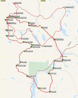
MAP
Roavve Polar Ultra 300. 20.-26 February 2015
First section of the track is the same as Rovaniemi150, so this section is very well signed and there is not need of GPS but the Satellite Device (mandatory) to do the check-in in mandatory waypoints. All mandatory waypoints in this first section match with the Rovaniemi150 Checkpoints. This checkpoints have a limit time, so if you arrive when checkpoint is closed maybe you wouldn't find the tent but you can use the wood if you want to do a fire.
Second section is quitte different, it follows an snowmobile track. There are signs, in some areas more than others. In some areas you will find very good snow conditions and in others maybe you find deep snow and also you will find other snowmobiles track crossing that all it do is confuse the right way... It all depends on how long ago snowed and when the last snowmobile went through there.
In this page you have all the information about the track in different formats to add it to your GPS.
Here it is the list of shelters. There are three different kind of shelters: Laavu, Kota and Cabin. Normally you can find wood in this public shelters and also an axe, but in some places wood could be little wet and no possible to find the axe. So be prepare just in case. In any case the public shelters are allways in very good conditions.


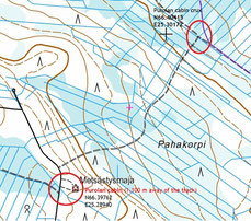

Keski Peurajärvi is 635 m out of the way. Purolan cabin is 1,1 km out of the way. Ahvenlampi laavu is 600 m out of the way.


This files are made with Expert GPS and GPS Visualizer free programs. The kmz file will open with Google Earth.
HERE YOU HAVE different Satellite Device. All of them are ok. Your choice depends about your needs. If you need some advice just contact us.
